Get out on the Blueway

Parts of the Mountains to the Sea trail are known as Blueways and the Neuse River runs through Johnston County and offers boat and canoe launch access.

Segments 11A-16A: The Neuse River Paddle Route

Smithfield to the Neusiok Trail

Map of the Blueways along the Mountain to the Sea trail in Johnston County.

By Sound Rivers and Friends of the Mountains-to-Sea Trail

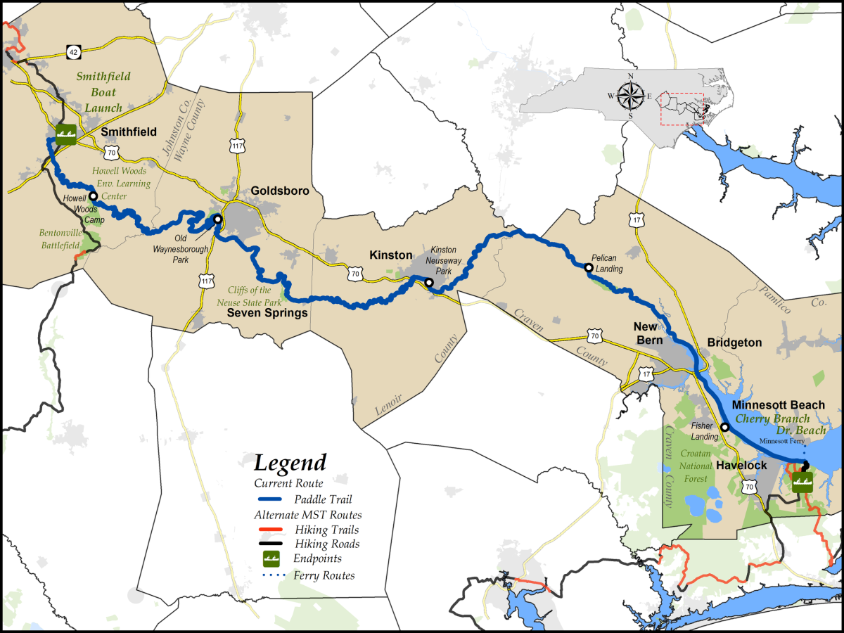
An alternative way to complete the MST through North Carolina’s coastal plain is to paddle the Neuse River for 170 miles from Smithfield to the northern end of the Neusiok Trail in the Croatan National Forest near Havelock.

The Neuse River runs 227 miles from Falls Lake to Pamlico Sound. Marking the Falls Lake dam as River Mile 0, the MST portion runs from River Mile 46.8 to 216.1.

Beginning as a fast-moving, narrow river, the Neuse gradually widens and slows, occasionally splitting into multiple channels. By the time it reaches the end of the MST paddle route near Pine Cliff Recreation Area, it has formed a 2.5-mile-wide estuary. The river flows on another eleven miles to empty into Pamlico Sound, where it spreads to five miles wide.

Throughout your paddle the shores are heavily forested, often with a wilderness feel. In places, the banks fall away at water level; in other places—notably Cliffs of the Neuse State Park—they can range as high as 90 feet above the river. Around every bend you will find new wonders: cypress swamps; sand banks and bars for camping; birds of every description (heron, kingfisher, osprey, warblers); and wildlife coming down to drink from the river.

The few towns along the river present welcome opportunities to get a meal, explore eastern North Carolina’s history, camp, or just take a break. In Goldsboro, Kinston, and New Bern (as well as in Cliffs of the Neuse State Park), you will find walking trails that State Parks has accepted for inclusion in a planned continuous MST hiking route paralleling the Neuse.

The lower portion of the Neuse River Paddle Trail changed significantly in September 2018 when Hurricane Florence devastated eastern North Carolina. Several recreation areas in the Croatan National Forest experienced such significant damage that they remain closed to this day, including Pine Cliff Recreation Area, the former end of this segment. Although we hope the recreation area will reopen soon, at this writing it is illegal to take out at Pine Cliff, and there is no access to the area for boat shuttles. Therefore, the ending point described in this guide is 1.0 mile down river, at a beach at the end of Cherry Branch Dr. The beach is privately owned, and we are grateful to the Cherry Branch HOA for graciously granting permission for MST paddlers to use the takeout. Please be respectful of private property. In addition, the current land-based route of the MST is no longer directly accessible from the ending point. Therefore, in this edition of the guide we have included hiking directions to the trailhead for paddlers wishing to continue their eastbound journey.

For an advance look at the route, take a virtual trip down the river using Google Earth or Apple Maps. In addition, we highly recommend using a good GPS device for navigation on the river. This guide provides coordinates to help locate nearly every feature on the river, many of which can be difficult to find from a boat. People interested in paddling the entire river should contact Sound Rivers for further information.

Free Visitors Guide
Get your free Visitors Guide today to learn about Johnston County and all it has to offer! Get the Guide
Sign up for our Event Newsletter